Today I went to visit the Golden Triangle. It's the most northernmost point I've ever been!
It's the point where the borders of Myanmar, Thailand and Loas meet, at the confluence (there's that word again) of the Ruak and the Mekong rivers. The
Golden Triangle has a long history which is described at the link but now the name is used to refer to the point where the borders of the three countries meet not the
regions drug production.
 |
| And this is it. Thailand on the left, the brown Ruak river, then Myanmar, then the Mekong , and Laos on the right. |
Once you get into the region there are several places along the river bank with big signs up for "The Golden Triangle", but the main viewpoint and where the GPS directed me to was the large buddist temple which is where the above view is from. This seemed to be the most popular spot too, the others looked like they were actually shops. But this being South East Asia there are stalls selling souvenirs everywhere anyway.
 |
| My bike in Thailand, Myanmar just across the Ruak, and Laos in the background over the Mekong. The gold dome is part of a Lao casino I think. |
 |
| More of the confluence of the Ruak and Mekong. It looked like the Mekong was trying to flow back up the Ruak. |
 |
| This is right next to the lookout... Suspicious prominent placement. The donated seats were more common in Laos but were mostly hotels or local businesses, I hadn't seen this sort of thing in Thailand before. |
 |
| The shiny big budda |
 |
| Buddhists praying at the base of the statue |
 |
| Behind the statue was this contraption. |
So what's happening here is that people would buy coins and then line up to climb a ladder to launch the coins down the ramps (the two rails with the flags) into the belly of the white budda at the bottom. And after each coin there is some automated voice saying something in Thai. I guess the simple 4 donation boxes on the other side of the big budda wasn't enough of an attaction, so they put up the branches nearby for people to attach notes to, and then when that wasn't enough they created this. The Buddhist
enlightenment-by-donation amusement
park.
 |
| It's not anatomically correct, I didn't get hit in the head by anything when I walked under. |
After that I visited the Opium museum. It's mostly what you would expect in there, lots of photos of the tribes, tools, poppies and everything else associated with opium. The most interesting thing were the
weights used to measure out the opium. There were small 2g brass weights all the way up to 1.6kg (a 'vis', a standard packaged amount of raw opium) in various shapes. Most of them were shaped in the form of the animals of the Chinese astrological calendar, but the Burmese weights were in the shape of the
Hinta bird.
They also had the "
Opium Pillows" which were used because the smoker would often lie on their side while smoking and require some kind of head support. Some were made out of softer materials like leather, but the majority were harder like ivory or stone. The description next to it said that the opium smoker often didn't care how hard the opium pillow was because after a while it just felt like their head was resting on a cloud. Indeed.
After the Museum I started to head back towards Chiang Rai, but trying to take the longer more mountainous way I saw on google maps.
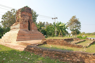 |
| Wat Tok Khong. Built in the 15th century, and in the middle of nowhere on the side of the road. |
My GPS kept trying to direct me back on the the main highway, but I ignored it for as long as possible until the mekong started heading east, then I figured I best turn back towards the west where Chiang Rai should be. I didn't ride over any mountains, or see any poppy fields, but I did see lots of villagers dressed in black, and lots of dogs, and lots of roadworks.
Tomorrow, it's off to Chiang Mai, or Pai. Probably Pai.


No comments:
Post a Comment